Saturday, June 23, 2007

Manning Park to Princeton: The Manning Park Ordeal, Denoument

Can things get worse than getting lost in the dark on a mountainside in bear country and ascending a near interminable mountain pass with no water? Well, yes. Sort of.


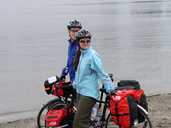
Hypothetically speaking, one might have to descend said mountain. In the dark. Unable to see the road ahead of you while you gather speed beyond your control, unable to use the shoulder because it's grated and, therefore, biking on the road and simply praying that motorists also gathering speed possibly beyond their control will see you in time. (Thank you Scotchbright. I think you might have literally saved our lives.) Hypothetically, of course. Uh, Mom, this totally NEVER happened.


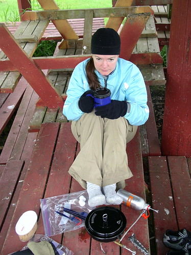
And then, blessedly, halfway down the mountain, you might finally see the campground that was supposed to be 50 kilometres back and think that your ordeal is finally over. Unbeknownst to you, however, is that this campsite is infested with Pterodactyl sized mosquitoes. Oh, and? It's COLD. Cold as in next-to-a-spring-damp-air cold. Cold as in above-the-snowline cold. The kind of damp cold that makes it impossible to start a fire. Wet cold that infiltrated our gear and dampened all our bedding. The kind of cold that even with wool socks, long underwear under full clothing, a fleece, toque, and gloves we shivered violently throughout the night instead of sleeping.

By morning, things were beyond bleak. We were exhausted and stiff. We ate our oatmeal in bleary-eyed silence and then a drop. And another drop. And then the heavens opened up and DUMPED. And dumped. And dumped. Lashing after lashing of wind and rain that persisted throughout our 70 kilometre ride to Princeton.

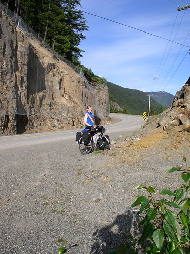
And it should be noted that somewhere in that ride, somewhere near the start of our ascent to Sunday Summit, I hit a wall. I rounded a corner and there was another damn hill. I stopped to collect my thoughts, trying to rally myself, but that damn hill just yawned ahead of us through the sheets of rain, no end in sight. (It should also be noted that there is nothing, NOTHING, that will cause my morale to nosedive more quickly and effectively than being cold without respite. I simply can't stand it.) I looked at the hill and the hill looked at me.

"Fuck it."

I got off and walked. I walked for two full kilometres just to spite the hill. And ridiculously, I felt much better after that. If there was something I could have done to spite the rain, I would have done that too.

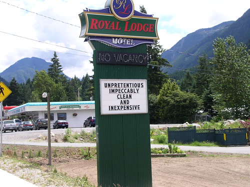
And then, finally, Princeton. We were back in civilization and it couldn't have come a minute too soon. In town, we ran into a man coming out of the hardware store and asked him about the local campground. He took one look at us, drenched and bedraggled, and suggested that we get a motel. We did. And we stayed for two nights because that's how long it took to warm up and sleep off the Park.

Stats: 70 km; Sunday Summit 1280m; 1 very much needed rest day

[Ed note: No time to spel cheque. Please forgive.]

Thursday, June 21, 2007

Oh, thank God!

It looks like we're going the right way!


On the right path...

In Princeton, BC

Wait...

P1010091

Hope to Manning Park: When You're Going Through Hell...

Keep going. (I think Winston Churchill said that.)


Ascending Allison Pass


This was a leg of the journey we'd been dreading and, not to ruin the suspense, it not only lived up to our expectations, it exceeded them. There's just nowhere but up from Hope. A whole lotta up.

First, there's the climb to the
Hope Slide, which according to Wiki, is a 7% grade. Or, simply put, bloody steep. We couldn't get our bikes up over five kilometres per hour, so it was slow going. Slow and...grinding. There just aren't enough spinning classes in the world to make that kind of climb any easier. For a while, I would set my sights on something about 400 metres ahead and make it my goal to just make it to that object ("I'm going to keep peddling to that big tree, just keep going until you get to the big tree, you're almost at the big tree, come on big tree, bigtreebigtreebigtreebigtree..."). This technique tricked my psyche into not sabotaging my determination for a good hour. As we moved into hour two of grinding up the hill, my psyche caught on to me ("I'm going to keep peddling to that hubcap on the side of the road, just keep peddling until--Oh sod it! This SUCKS. This hill SUCKS. Suckssuckssuckssuckssuckssucks...").

All told, the climb took almost three hours. We were tired. And lunch overlooking a devastating landslide that killed a number of people wasn't quite what we needed to hearten our flogging spirits.

We checked the map and came up with a plan. There was no way we were up to the challenge of the notorious
Allison Pass, but according to our map, we had a nice long descent into the Sunshine Valley, another shorter climb out of the valley and then a descent into a campground at the base of Allison Pass. We decided to aim for that campground and to tackle Allison Pass in the morning when we had fresh legs.

The Sunshine Valley came and went and the second climb and its descent came and went and there was no campground. We were tired, daylight was flattening into dusk, and we were out of water. We reasoned that the second descent must have just been a dip and that we would have to climb up a bit further before coming down to the campground we were looking for, so we started up the next climb. In any case, there was nothing else to be done, as we were on the side of a mountain in the middle of nowhere.

An hour later, we were still climbing and the more we climbed, the steeper it got. At some point, a car crossed over the centre line and the driver rolled down his window to inform us that about halfway up the hill there was a big bear. This news was alarming in two ways: first there was a bear, a big bear at that and second, we had been climbing for an hour and we weren't yet halfway up the hill.

There was, indeed, a bear further up the hill. And he was big. But not Grizzly big, thank God (I'm more scared of Grizzlies, but perhaps only because I haven't encountered as many). (No, seriously, aren't Grizzlies more menacing?) The bear--a Brown Bear, I think--was on the shoulder on the opposite side of the road. Which is to say, much closer than I ever care to come to a bear. Kieran dug out the bear spray and had it ready in his handlebar bag and we start ringing our bike bells and talking while we approached. The bear didn't get scared off, but instead became curious and turned to take us in, sniffing the air in our direction. When we were close enough to make eye contact (ungerrrt!), the bear would turn his head sideways to avoid direct eye contact (not confrontational--PHEW!) and then look back (ungerrrt!). We did the same, and I'm sure it was for the same reasons as the bear, a kind of "I see you, but I do not want you to attack me. But I have to keep an eye on you, so I see you. But let's not fight." This dance of eye contact and looking away continued for a few long, heavy moments and then, blessedly, a truck driver saw our predicament and pulled into the centre lane, slowed to our pace, and placed the length of his trailer between us and the bear and escorted us up the hill until we were a safe distance from the bear. I turned to look back at the bear and saw that he'd done the same, craning his neck around to get a good look at us (or likely to get a good whiff, as I'm not sure how well bears can see).

Post bear excitement, we had another three hours of climbing. Still convinced we were on the smaller hill, we kept expecting the hill to end at each turn and then another hour of uphill riding would follow. At one point, I felt a cold rush against my calves and realized I had just ridden past a snow bank. We were past the snow line and we were still going up!

The last of the daylight drained away and we pulled over to put our lights on and that's when we saw this:


Summit of Allison Pass: 1342m

We'd accidentally done Allison Pass. All 1342 metres of altitude (in a mere four hours! And with only one bear encounter! Oh, the FUN!).

Stats: 67 kms; 1342m altitude; 1 bear sighting; 2 broken spirits

And, for those who are interested, here's Manning Park on Google Maps.

Signs, signs, everywhere signs

We've decided to create a new category for pictures of the crazy signs we keep seeing as we travel, largely inspired by this first sign that got us to giggling.

Tired of all those pretentious roadside motels? This is the place for you!


Well, only if it's unpretentious!

Tuesday, June 19, 2007

Agassiz to Hope: The Deluge

Trying to warm up in Agassiz


The (first) day of torrential rains. Driving rain that hammered into the tent loud enough to wake us up with a start. We lay in bed for over an hour, hoping the rain would stop so that we could get out of the tent but instead the storm intensified with each passing minute. Kieran was the first to brave the rain and he dragged all our gear into a nearby gazebo where a number of picnic tables had been stacked and stored.

We spent the morning huddled in the gazebo, sitting on upturned picnic tables and watching the icy silver sheets of rain billowing of the roof. We spread out our gear on the picnic tables, feebly hoping it would dry out enough for us to re-pack it. Everything was wet, the tent, the bedding, our clothes and, most tragically, my wool socks.

Eventually, we accepted that the rain was not going to let up. We decided to do the short ride into Hope where we could get a room. A little rain would have been fine, but this was not a little rain. This was biblical.

Our outlook improved somewhat in Hope because we came across our first one of these photo opportunities:

Keener Rambo

We have since resolved that we will stop for every single one of these damn things that we come across. (Aside: Is there an official name for these stick-your-head-in-the-hole-and-take-a-picture things?)

Stats: 40 km travelled; 4 wet feet; 1 head-in-the-hole picture
Total distance: 184 km

Langley to Agassiz

P1010038

Our first successful day. Our first great day (and our last for a while). Both the weather and the scenery in the Fraser River Valley were ideal and right away I was struck by how different it is to cycle through an area than to drive through it. It seems like you see so much more or just...really take things in. There's birds calling back and forth and butterflies and eagles soaring and the smell of flowers blooming along fences and it's all happening at once. And then of course there's the cows. We never fail to arouse the curiosity of cows, which in turn never fails to crack us up.

The Dewdney area was the surprise highlight of the day for both us. It was sweet and pretty in a nostalgic pastoral kind of way, with the snow capped mountains in the distance and the pastures dotted by buttercups. I was also surprised to see vineyards in the area, as I didn't know grapes could grow in the Lower Mainland (wait, is Mission Hill wine from Mission?).

We ended our idyllic day of riding through rolling hills by setting up Big Agnes under a weeping willow in Agassiz and we both fell asleep relaxed and secure in the knowledge that things were going to be okay and the trip was going to be a success.

Stats: 84 km; 1 flat tire (mine of course); and we both achieved a new speed record of 56kph
Total distance travelled: 144km